SwitzerlandTHE GROSSE ALETSCH GLACIER
Switzerland's Aletschgletscher, or Aletsch Glacier, is the largest in the European Alps, and because of its sheer size it is (mercifully) shrinking less rapidly than most other glaciers. The region around it is an UNESCO World Heritage Site due to rare flora and fauna as well as the retreating glacier.
Seeing the glacier from afar at one of the many vantage points as well as close up to appreciate the immensity of the ice is highly recommended.
I have visited two villages near the glacier: Bettmeralp and Fiescheralp. Both are car-free villages accessible by cable-car: Betten is the ground-station for Bettmeralp and Fiesch is the ground-station for Fiescheralp. If travelling by car, there are parking spaces at both of the ground-stations (Around CHF 10-15 per 24 hrs) and if by train it is even more simple, as the train stations link to the cable car stations.
...
 Bettmeralp's 'village green'
When it comes to charming architecture, Bettmeralp is the winner, mainly due to its beautiful chapel overlooking the Rhône valley, and its view across to the Valais Alps including the distant Matterhorn.
...
 View from Fiescheralp
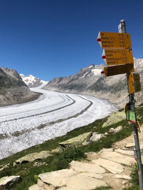
Fiescheralp is much smaller, but we found that accessing the glacier from here is easier, thanks to a rather random tunnel called the Oberes Tälli. Seeing this tunnel on a map and knowing nothing about it, we decided to hike up to it and take a look.
...

I have marked the tunnel on the map below in yellow; the entrance from the Fiescheralp side is arrowed in red.

The tunnel itself is very long and dark: bring a head-lamp or well-charged phone to help light the way! There are usually puddles (some deep) along the way and you may have to move against the wall to allow the passage of one of the rare local vehicles! The literal light at the end of the tunnel seems to be in the far distance but the long walk in the darkness is rewarded by a view of the Märjelensee, and the glacier suddenly seems amazingly close!


A rocky track takes you further downhill as you edge closer and closer to the entry point for the glacial hikes. We trusted our boots to keep their grip on the rocks, smoothed and polished by centuries of glacial activity, until finally we were able to set foot on the ice. Hiking boots are not suitable for walking on the glacier, so we posed for a quick photo and left those who had paid for crampons (and for a guide!) to navigate their way across the ice.


We then commenced our hike towards the Bettmerhorn, gaining altitude and making our way along the glacial valley. From early vantage points it is possible to see all the way up to the Sphinx Observatory, which is something that can be viewed from the Jungfraujoch (I was up there many years ago!). To look back onto the Aletsch Arena is something I had always wanted to do, but it is not quite possible from Bettmeralp and the Bettmerhorn, as the curvature of the glacier prevents this.
The Sphinx is at the left hand edge of the picture, on top of the grey mass of rock

We hiked via the Roti Chumme, all the way up to the Bettmerhorn. It is possible to stop here for food and drinks. From here, the hike back to Fiescheralp via the Hohbalm is downhill all the way. We decided to take the cable car down to Bettmeralp, stop for refreshments, then hike back to Fiescheralp. The round trip was around 20kms! It was a big day- especially given that I was not 100% fit: I was Day 8 post COVID!
 Make use of your panorama mode when you're up there!

 Scenery from Bettmerhorn Viewpoint
There are countless other hiking paths to explore in the area but the route we chose must be the most spectacular! The map is easy to find on-line (I recommend downloading the Swiss Mobility App, or https://map.schweizmobil.ch. It is an interactive map, and if you're doing any hiking in Switzerland this is an absolute must. Otherwise the hiking map at aletscharena.ch is OK.
Of course, if the weather is clear you must look out for the tiny Matterhorn wayyyy across the valley. Seeing its unique shape from about 50 kms away still gives me a thrill!

SwitzerlandTHE GROSSE ALETSCH GLACIER
Switzerland's Aletschgletscher, or Aletsch Glacier, is the largest in the European Alps, and because of its sheer size it is (mercifully) shrinking less rapidly than most other glaciers. The region around it is an UNESCO World Heritage Site due to rare flora and fauna as well as the retreating glacier.
Seeing the glacier from afar at one of the many vantage points as well as close up to appreciate the immensity of the ice is highly recommended.
I have visited two villages near the glacier: Bettmeralp and Fiescheralp. Both are car-free villages accessible by cable-car: Betten is the ground-station for Bettmeralp and Fiesch is the ground-station for Fiescheralp. If travelling by car, there are parking spaces at both of the ground-stations (Around CHF 10-15 per 24 hrs) and if by train it is even more simple, as the train stations link to the cable car stations.
...
Bettmeralp's 'village green'
When it comes to charming architecture, Bettmeralp is the winner, mainly due to its beautiful chapel overlooking the Rhône valley, and its view across to the Valais Alps including the distant Matterhorn. ...
View from Fiescheralp
Fiescheralp is much smaller, but we found that accessing the glacier from here is easier, thanks to a rather random tunnel called the Oberes Tälli. Seeing this tunnel on a map and knowing nothing about it, we decided to hike up to it and take a look.
...
I have marked the tunnel on the map below in yellow; the entrance from the Fiescheralp side is arrowed in red.
The tunnel itself is very long and dark: bring a head-lamp or well-charged phone to help light the way! There are usually puddles (some deep) along the way and you may have to move against the wall to allow the passage of one of the rare local vehicles! The literal light at the end of the tunnel seems to be in the far distance but the long walk in the darkness is rewarded by a view of the Märjelensee, and the glacier suddenly seems amazingly close!
A rocky track takes you further downhill as you edge closer and closer to the entry point for the glacial hikes. We trusted our boots to keep their grip on the rocks, smoothed and polished by centuries of glacial activity, until finally we were able to set foot on the ice. Hiking boots are not suitable for walking on the glacier, so we posed for a quick photo and left those who had paid for crampons (and for a guide!) to navigate their way across the ice.
We then commenced our hike towards the Bettmerhorn, gaining altitude and making our way along the glacial valley. From early vantage points it is possible to see all the way up to the Sphinx Observatory, which is something that can be viewed from the Jungfraujoch (I was up there many years ago!). To look back onto the Aletsch Arena is something I had always wanted to do, but it is not quite possible from Bettmeralp and the Bettmerhorn, as the curvature of the glacier prevents this.
The Sphinx is at the left hand edge of the picture, on top of the grey mass of rock
We hiked via the Roti Chumme, all the way up to the Bettmerhorn. It is possible to stop here for food and drinks. From here, the hike back to Fiescheralp via the Hohbalm is downhill all the way. We decided to take the cable car down to Bettmeralp, stop for refreshments, then hike back to Fiescheralp. The round trip was around 20kms! It was a big day- especially given that I was not 100% fit: I was Day 8 post COVID!
Make use of your panorama mode when you're up there!
Scenery from Bettmerhorn Viewpoint
There are countless other hiking paths to explore in the area but the route we chose must be the most spectacular! The map is easy to find on-line (I recommend downloading the Swiss Mobility App, or https://map.schweizmobil.ch. It is an interactive map, and if you're doing any hiking in Switzerland this is an absolute must. Otherwise the hiking map at aletscharena.ch is OK.
Of course, if the weather is clear you must look out for the tiny Matterhorn wayyyy across the valley. Seeing its unique shape from about 50 kms away still gives me a thrill!
Read similar posts