SwitzerlandVIA ALPINA (SWITZERLAND) PART 1
DAY 1 - A “PREPARATION WALK”: AESCHER-WILDKIRCHLI
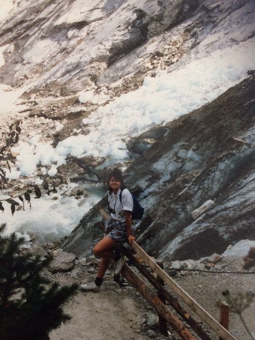
Having arrived in Zürich (from Australia) early in the morning, it was decided that the best thing to help shake off the jet-lag was a good uphill walk (with our backpacks, of course!). We had always wanted to see the Gasthaus Aescher Wildkirchli in the heart of the Appenzell so we had pre-booked the lovely Hotel Alpenrose (thanks to Google Earth showing its proximity!). We found the climb quite taxing at times, though we did have a pretty good excuse for stopping occasionally to catch our breath!
Gasthaus Aescher Wildkirchli is partly built into the cliffside of the Ebenalp.

 Nearby is the 400-year-old Wildkirchli cave-church. We purchased lunch at the Gasthaus, which does have cheap rooms for those who don’t mind the fact that there are no showers (rainwater only). From the Gasthaus it is possible to walk down to the beautiful and serene Seealpsee, and I recommend a walk along the shores of this lovely lake. (Due to time constrictions, we had to leave the Seealpsee until a later visit).

We needed a little more comfort for our first night, considering the long-haul flight we had just endured. Thus, we took a short walk from the cave-church up to the cable-car station, took the cable car back down to Wasserauen and had an early dinner in our hotel. Staying awake for the entire day helped us overcome most of the jet-lag, and we were ready to travel to Elm, the starting-point of our via Alpina experience.
 Gasthaus Alpenrose, in Wasserauen
DAY 2- ELM 24/7 :
Arrived on a rather wet Monday afternoon. Trains took us from Wasserauen to Schwanden, then the Elm postal bus dropped us at a small group of shops; Hotel Elmer was just across from these. The hotel appeared to be closed, but when we asked at the shops across the street, the proprietor nodded and asked us to wait, and presently a woman appeared with a key to the front door! Monday was the “Ruhetag”, but apparently the hotel was open for us and just one other couple. Other places also appeared to be closed for the week; re-opening on 1/8 for Swiss National Day. We had a chance to explore Elm, and it is a small, scenic village with one large manufacturing plant which bottles the (“pure and unadulterated”) mineral water found in the region. With many places closed, we found it very quiet and peaceful.
DAY 3- ELM to LINTHAL: THE RICHETLIPASS, 25/7:
We met the other couple staying in the hotel at breakfast, as we were all discussing the wet weather. They were Italian, and had already commenced their Via Alpina adventure by coming over the Foopass the previous day. Our (different) guidebooks warned against crossing the Richetlipass in wet weather, so the Italian couple decided to walk down to Schwanden and take the train from there to Linthal (the next stop). Also, the very friendly woman supervising the breakfast had warned us that snow was likely to fall up at higher levels! We, being eager to start our big adventure, unwisely defied the warnings and decided we would risk it. We decided to take the chairlift to Ämpächli to cut out part of the ascent. As it turns out, it would have been easier to wait for the postal bus to take us to Obererbs, as this would have cut out more of the walk, which- in that kind of weather- is always a good idea.


The initial hike was quite pleasant, as it was in a sheltered area, and the rain had temporarily stopped. After Obererbs it returned, and we met a rather cold and wet lone walker from Scotland who had come down from the Richetlipass. He looked a little doubtful when we asked if we’d be OK (as we were not suitably dressed for very cold conditions), warning that there was, indeed, snow on the pass- and it was very slippery on the initial descent. We were determined to keep going and we eventually reached the top with a feeling of achievement. I wondered why there was no snow, and why the descent was not steep at all, and why couldn’t we see Linthal? I soon realised that the Richetlipass was the snow-covered (and much higher) pass in the distance, and we had merely crossed the Jochpass into the valley of Winkelmatt. It was around this time that we noticed another (foolhardy!) group ahead of us who, after having a rest at the Winkelmatt hut (and drinks offered by the welcoming farmer), were aiming to cross the Richetlipass. I was grateful for their presence, as I would have been terrified if I was guiding my poor husband over a pass that should never have been attempted in that weather!


This group also allowed us to see where the very narrow track was heading. The rain turned to sleet and then into snow as we ascended further towards the pass. I caught up with them at the top of the Richetlipass, but they forged ahead, leaving us to negotiate the narrow and slippery track down towards Linthal, which was still out of view.


 Both of us fell at least once; my husband actually fell onto one of his walking poles and bent it 90 degrees, so that was the end of that pole! I felt rejuvenated after completing the steep part of the descent and coped well with the very long walk down to the village. Eventually we met with the road down to Linthal, and I was happy and relieved, but hubby was almost spent, and needed many words of encouragement to make it into Linthal.
 I was keeping a close eye on the time, as my aim was to catch the second-last funicular up to the car-free village of Braunwald at 19:55, the final departure being at 20:25.
By the time we reached the funicular he was barely able to put one foot in front of the other! We made it to the funicular station with 5 minutes to spare, and fortunately, with me taking my husband’s backpack and by calling a taxi (electric buggy) from the top funicular station to our Braunwald hotel, we were able to sit down to dinner before the kitchen closed for the night! The staff at Alexander’s Todiblick were wonderful, noting we were wet through and exhausted, and gave us the key to their drying room. My husband’s backpack had taken on some water (despite the so-called rain-proof cover), so many of his clothes were soaked. This would have significantly increased the weight he was carrying, so that certainly would have contributed to his state of near-exhaustion! All our clothes were dry by the following morning, and the hotel owner kindly supplied us with a large plastic bag to fit inside my husband’s backpack and prevent his clothes from any further waterlogging.
 Our transport in Braunwald!
DAY 4- BRAUNWALD to KLAUSENPASS HOTEL, 26/7:
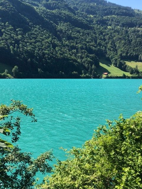
2017: 'Our wish is to return to Braunwald one day, as we did not see any of the beautiful views.'
 EDIT: We DID return to Braunwald in 2022 and just look at that view!
Definitely worth the trip!
EDIT: We DID return to Braunwald in 2022 and just look at that view!
Definitely worth the trip!
2017:
Again, the weather let us down- it was wet and cloudy, so the whole village was enshrouded in fog. Any thoughts of tackling a walk were soon put to rest because my husband’s arm was very sore after one of yesterday’s falls (the one involving his ill-fated walking pole!) and it was decided we should see a doctor. Again, the owners of Alexander’s Todiblick came to the rescue, booking as an appointment and sending us off in their delightful horse and buggy with directions from the bottom funicular station. It turned out that the place was next to the Braunwald funicular carpark entrance, and hubby received exemplary care and treatment, as only the Swiss can give. A fracture would have meant the end of our adventure; therefore we breathed a huge sigh of relief when told that it was just a tendon strain, and off we went on the postal bus headed for the Klausenpass. As it was still raining intermittently, this was a sensible choice. Urnerboden looked lovely and we would love to explore the area in detail one day, but we were glad to be observing from the warm and dry interior of the postal bus. We stopped to pick up 2 drenched hikers who turned out to be our Italian friends! After telling our Richetlipass (and doctor’s visit) story, they told us that their walk to Schwanden was long and very damp, with no drying facilities at their Linthal hotel. They had braved the conditions and walked thus far, but the small stream crossings had turned into raging torrents and their boots were sodden inside and out, so they terminated the walk and let the bus take them the rest of the way. We spoke again at the Klausenpass Hotel, where there is time for refreshments between the bus arriving from Linthal and the bus leaving for Burglen, and they told us they were staying down in Spiringen overnight. We were happy to settle into our room in this 105-year-old hotel, furnished with old-fashioned wash-bowls and ewers, feeling as if we were still in the early 20th century. When we eventually learned that the building is soon to be demolished we were shocked. It contained so much history, from the photos of long-ago car rallies- the ladies dressed in their Victorian finest- to the old crockery and cutlery stored in its cabinets.
 The (now demolished) Klausenpass Hotel
 The ewer and bowl on the nightstand in our room
 New Klausenpass Hotel (2022)
 View from the Klausenpass- spectacular!
DAY 5- KLAUSENPASS HOTEL to RATZISMATT 27/7:
Today was a brighter day, though there were one or two intermittent showers. The planned walk was relatively easy; no steep ascents/descents, and only about 11 kms to our farmhouse (“Schlaf im Stroh”) stopover, discovered on the “My Switzerland” website. It was a pleasant walk, and the fact that we were deviating from the actual Via Alpina meant that the Maps App. on my smart phone was essential.


 Pics from the walk from Klausenpass to Ratzismatt
.
.
.
We arrived early and claimed the mattresses upstairs, then the next group of 5 people arrived. We were pleasantly surprised to find it was the German group who we followed over the Richetlipass! It was good to have the opportunity to further converse with this group (the youngest spoke excellent English and was able to translate for the others!), and we heard more stories of their walks and where they were headed. Another 4 people arrived later: a Swiss family with 2 kids, and we all sat around the dinner table enjoying the beautiful food. Needless to say, the barn was packed with people that night. We slept well, but we heard that a few of the “straw sleepers” downstairs had to deal with loud snoring and cold conditions, so they looked very tired at breakfast! We all said our goodbyes, as the German group were splitting up and 3 were returning home. The hospitality of the owners of the farm, the Müller family, will not be forgotten.
 View from our barn window!


 Scenes from Ratzismatt
DAY 6- RATZISMATT TO LAKE LUCERNE, 28/7:
A relatively short walk to the Seilbahn Spiringen-Ratzi was planned, but this cable car would take us to Spiringen, which would then necessitate more walking or a bus ride down to Altdorf. I changed plans and decided we would walk to the Luftseilbahn (cable car) Brügg-Rietlig-Biel (next to Berggasthaus Biel), which took us nearer to Burglen, then travel the short distance to Altdorf by bus.
We reached the Berggasthaus Biel after a 1 ½ hour walk (including the time to retrace our steps after a wrong turn: the signage as you near the guesthouse is a little confusing!). The weather was showery, but as the morning wore on it seemed to be brightening up a little. The guesthouse was very quiet (given the weather and low clouds), and we were directed through a side door to the top station of the Luftseilbahn. No-one was around, and a cabin was sitting there, idle. Instructions were pinned to the noticeboard, but here my basic Swiss-German failed me. We were saved by a local teenage girl and her younger male cousin, the latter of whom very kindly lifted the receiver of the wall phone, spoke rapidly in Swiss-Deutsch and told us (the girl translating) that we would leave in 8 minutes. We were able to have a bit of a conversation whilst we waited, and learned that the girl was helping at her Uncle’s farm during her school holidays, and that they were on their way to buy some paint for their chicken coop! Of course, we were off after the 8 minutes as promised, and we had to disembark at the Mittelstation to pay the fare whilst the cabin waited for us. We re-embarked, along with a Luftseilbahn employee, and we were rather puzzled by an unscheduled stop at one of the towers. The man activated a special platform and out he stepped into the body of the tower, returning with a tiny rodent in a cage. After some discussion we eventually arrived at the word “chipmunk” (we English/Aussies had never seen one) and we were told that they are pests that can chew through wires and ground the whole gondola system. They are obviously good climbers as well!
This gondola is obviously a little off the main tourist trails of Switzerland. Taking this route did save us a little time, though it was the same bus route we took (the lower part of the Klausenstrasse) to Altdorf as that from Spiringen.
 The Telldenkmal at Altdorf
From my research, even in fine weather the route from Unterschachen to Altdorf is not really worth the time taken, and the postal bus is the better option. Others may differ in their opinion, and there are the devoted hikers who may wish to claim that they walked the entire route. We met a young French couple who were doing just that- and camping in a tent every night (often illegally). This certainly was not for the faint-hearted, especially in the wet weather in which we met (as they were trying to dry out their tent!). I hope the rest of their journey had a little more sunshine!
Altdorf is a nice little Swiss town, and the Telldenkmal (William Tell Monument) is worth a visit, as it was in this city that William Tell famously shot the apple off his son’s head . It stands in the market square (Rathausplatz) of Altdorf, and the old tower behind is also worth exploring. There are walks up to Eggberge (the sun terrace) and lovely views.
We stopped only briefly in Altdorf on our way (via bus and train) to Weggis, which sits on the shore of the Vierwaldstättersee (Lake of Lucerne). We had 3 days of rest, enjoying the beautiful sunshine whilst hubby’s arm was healing, and our sore muscles and blistered feet recovering. Our lakeside hotel, the Beau-Rivage, was our "splurge" hotel for this trip and we enjoyed the old-fashioned service and luxury of the place.


 Scenes from Weggis and the Beau-Rivage
Day trips from Weggis/ Lake Lucerne:
Lucerne:
A major tourist centre, famous for its old wooden pedestrian bridge (Kappellbrücke), most of which was rebuilt after a tragic fire in 1993. Only a handful of the original paintings from the bridge survive today.

The Lion Monument (Löwendenkmal) is beautiful, but I found it very sad, and I didn’t want to stay looking at such a sorrowful rock carving. It depicts a dying lion. Apparently I’m not the only one that feels this way!

Of course, there’s the shopping. But unless you are purchasing a small item of jewellery or replacing an item you’re already carrying, it may be best to avoid temptation!
.
.
.
Vitznau: We took the lake steamer from Weggis (highly recommended to any destination, as the views are just wonderful!), and at the tourist information centre just up the road we obtained a map of the walking trail around Vitznau. It was a very enjoyable, easy hike ascending to some lovely viewpoints, passing a waterfall and crossing the tracks of the narrow-gauge railway up to Rigi.


 (Scenes from our Vitznau hike)
Rigi:
Set aside a whole day to visit this small mountain (ie small when compared to most of its neighbours!), but don’t go if the weather isn’t clear. The 360 degree views from the top are amazing, and you can see across to the Bernese Alps, as well as to closer mountains like Titlis and Pilatus. You can take the cable car from Weggis and return via Vitznau by train, then back to Weggis on the lake steamer (a “Rundfahrt” or round-trip). There are various cafes and places of interest. You can also walk up and/or down if you are not in a “rest phase”!!!
 Just look at that breathtaking scenery! View over towards Mt. Titlis, and the Bernese Alps.


More scenes from Rigi
DAY 9- LAKE LUCERNE->ALTDORF to BRÜSTI, 31/7:
After 3 days of R&R, we started back where we had left off: in Altdorf. We made our way to Attinghausen and walked uphill to the little Attinghausen-Brüsti cable car, paying at the Mittelstation as we had before. Very keen walkers may choose to hike all the way up, but we knew what we had in store for us the next day.
The Berggasthaus Brüsti, at the top station, was undergoing renovations at the time, but is now open. It may be worthwhile researching this place as overnight accommodation. We had a 10-minute walk to reach our destination: the Berggasthaus Z’graggen. A fairly basic guesthouse run by a hippie couple, the food was edible…but that’s all I will say. We went for an evening walk, and there- on the horizon- sat the Surenenpass, beckoning us to cross. Thankfully, it didn’t look too daunting!
 Approaching Attinghausen
 View from Brüsti
 The Surenenpass can be seen from Brüsti
DAY 10- BRÜSTI TO ENGELBERG: THE SURENENPASS, 1/8 (Swiss National Day)
The day dawned clear and sunny, and we keenly set off early. The Chraienhöreli ridge was tackled first- in photos it looked more difficult than it actually was- and soon the Brunnistock seemed to be within arm’s reach to our right. I was a little in awe of this mountain, as the guidebooks warn that it is known for its disintegrating rock walls, causing stones and boulders to come tumbling down towards hikers! This was obvious, as we picked our way over renewed sections of the track, modified to overcome an area of landfall. I was glad to be finally climbing up the last few steps to the pass.
 The Chraienhöreli
 The Surenenpass is in sight!
 The rocky Brunnistock
 Nearing the top!
It is only at the top of the Surenenpass that the mighty Titlis comes into view. I had seen photos in the guidebooks, but none of them passed on this information.
 It's an awesome feeling when you reach the pass! (Titlis is centre of the pic)
.
.
.
The downhill hike is much longer and more gradual than the ascent. We paused at Blackenalp for a drink, and the chapel described in the guidebook is, indeed, tiny and charming! A storm was brewing on the horizon and we decided to head for Fürenalp cable car station. It was on this trail that we became confused, and we were stopped by a helpful café owner as we walked by, asking where we were headed. As it turned out, we had descended too far (to Äbnet). We were directed back uphill (2 sides of a triangle) and zig-zagged as we ascended to a high trail that led to the Fürenalp Restaurant. It seemed deserted but, as it turned out, the friendly owners were packing up and about to leave for Engelberg (for fear of being stranded by the approaching storm). The top station of the Fürenalpbahn is part of the Fürenalp Restaurant complex, so we waited for them, and travelled down together. This time we paid at the end of the journey.
 Scene from the pass
 Plenty of cows on the way down!

Beautiful scenery as we head down to Engelberg
.
.
.
The bus ride from the lower station is free, but you need to know where to disembark, as it takes you to various points around Engelberg, and this is not a small village! This is where your smartphone and Google Maps come in very handy! I later discovered that I could have saved Swiss francs (CHF) by purchasing a “Kombiabonnement” (Hiking Circuit) Ticket for both Attinghausen-Brüsti and Fürenalp-Engelberg gondolas. Hindsight is a wonderful thing, as they say!
Being Swiss National Day, Engelberg was in party mode. We washed (ourselves and our clothes!) and rested briefly whilst the storm hit, bringing copius amounts of rain. As soon as it cleared we headed into the main part of the village, joining the locals for beer, wine and bratwurst. Unfortunately another storm front moved across, so we headed back to the hotel. The weather eventually cleared a little, so the annual fireworks show wasn’t completely ruined, and we had a good view over the town from our window. Sunny weather was forecast for the following day, so we went to bed anticipating a good day’s walk to Engstlenalp.
HOPE YOU HAVE ENJOYED PART 1
... AND NOW ON TO VIA ALPINA PART 2!
FOR ALL THE HINTS (SUCH AS WHAT TO PACK), AND TO SEE WHERE IT ALL BEGAN, PLEASE READ "THE BEGINNING".
SwitzerlandVIA ALPINA (SWITZERLAND) PART 1
DAY 1 - A “PREPARATION WALK”: AESCHER-WILDKIRCHLI
Having arrived in Zürich (from Australia) early in the morning, it was decided that the best thing to help shake off the jet-lag was a good uphill walk (with our backpacks, of course!). We had always wanted to see the Gasthaus Aescher Wildkirchli in the heart of the Appenzell so we had pre-booked the lovely Hotel Alpenrose (thanks to Google Earth showing its proximity!). We found the climb quite taxing at times, though we did have a pretty good excuse for stopping occasionally to catch our breath!
Gasthaus Aescher Wildkirchli is partly built into the cliffside of the Ebenalp.
Nearby is the 400-year-old Wildkirchli cave-church. We purchased lunch at the Gasthaus, which does have cheap rooms for those who don’t mind the fact that there are no showers (rainwater only). From the Gasthaus it is possible to walk down to the beautiful and serene Seealpsee, and I recommend a walk along the shores of this lovely lake. (Due to time constrictions, we had to leave the Seealpsee until a later visit).
We needed a little more comfort for our first night, considering the long-haul flight we had just endured. Thus, we took a short walk from the cave-church up to the cable-car station, took the cable car back down to Wasserauen and had an early dinner in our hotel. Staying awake for the entire day helped us overcome most of the jet-lag, and we were ready to travel to Elm, the starting-point of our via Alpina experience.
Gasthaus Alpenrose, in Wasserauen
DAY 2- ELM 24/7 :
Arrived on a rather wet Monday afternoon. Trains took us from Wasserauen to Schwanden, then the Elm postal bus dropped us at a small group of shops; Hotel Elmer was just across from these. The hotel appeared to be closed, but when we asked at the shops across the street, the proprietor nodded and asked us to wait, and presently a woman appeared with a key to the front door! Monday was the “Ruhetag”, but apparently the hotel was open for us and just one other couple. Other places also appeared to be closed for the week; re-opening on 1/8 for Swiss National Day. We had a chance to explore Elm, and it is a small, scenic village with one large manufacturing plant which bottles the (“pure and unadulterated”) mineral water found in the region. With many places closed, we found it very quiet and peaceful.
DAY 3- ELM to LINTHAL: THE RICHETLIPASS, 25/7:
We met the other couple staying in the hotel at breakfast, as we were all discussing the wet weather. They were Italian, and had already commenced their Via Alpina adventure by coming over the Foopass the previous day. Our (different) guidebooks warned against crossing the Richetlipass in wet weather, so the Italian couple decided to walk down to Schwanden and take the train from there to Linthal (the next stop). Also, the very friendly woman supervising the breakfast had warned us that snow was likely to fall up at higher levels! We, being eager to start our big adventure, unwisely defied the warnings and decided we would risk it. We decided to take the chairlift to Ämpächli to cut out part of the ascent. As it turns out, it would have been easier to wait for the postal bus to take us to Obererbs, as this would have cut out more of the walk, which- in that kind of weather- is always a good idea.
The initial hike was quite pleasant, as it was in a sheltered area, and the rain had temporarily stopped. After Obererbs it returned, and we met a rather cold and wet lone walker from Scotland who had come down from the Richetlipass. He looked a little doubtful when we asked if we’d be OK (as we were not suitably dressed for very cold conditions), warning that there was, indeed, snow on the pass- and it was very slippery on the initial descent. We were determined to keep going and we eventually reached the top with a feeling of achievement. I wondered why there was no snow, and why the descent was not steep at all, and why couldn’t we see Linthal? I soon realised that the Richetlipass was the snow-covered (and much higher) pass in the distance, and we had merely crossed the Jochpass into the valley of Winkelmatt. It was around this time that we noticed another (foolhardy!) group ahead of us who, after having a rest at the Winkelmatt hut (and drinks offered by the welcoming farmer), were aiming to cross the Richetlipass. I was grateful for their presence, as I would have been terrified if I was guiding my poor husband over a pass that should never have been attempted in that weather!
This group also allowed us to see where the very narrow track was heading. The rain turned to sleet and then into snow as we ascended further towards the pass. I caught up with them at the top of the Richetlipass, but they forged ahead, leaving us to negotiate the narrow and slippery track down towards Linthal, which was still out of view.
Both of us fell at least once; my husband actually fell onto one of his walking poles and bent it 90 degrees, so that was the end of that pole! I felt rejuvenated after completing the steep part of the descent and coped well with the very long walk down to the village. Eventually we met with the road down to Linthal, and I was happy and relieved, but hubby was almost spent, and needed many words of encouragement to make it into Linthal.
I was keeping a close eye on the time, as my aim was to catch the second-last funicular up to the car-free village of Braunwald at 19:55, the final departure being at 20:25.
By the time we reached the funicular he was barely able to put one foot in front of the other! We made it to the funicular station with 5 minutes to spare, and fortunately, with me taking my husband’s backpack and by calling a taxi (electric buggy) from the top funicular station to our Braunwald hotel, we were able to sit down to dinner before the kitchen closed for the night! The staff at Alexander’s Todiblick were wonderful, noting we were wet through and exhausted, and gave us the key to their drying room. My husband’s backpack had taken on some water (despite the so-called rain-proof cover), so many of his clothes were soaked. This would have significantly increased the weight he was carrying, so that certainly would have contributed to his state of near-exhaustion! All our clothes were dry by the following morning, and the hotel owner kindly supplied us with a large plastic bag to fit inside my husband’s backpack and prevent his clothes from any further waterlogging.
Our transport in Braunwald!
DAY 4- BRAUNWALD to KLAUSENPASS HOTEL, 26/7:
2017: 'Our wish is to return to Braunwald one day, as we did not see any of the beautiful views.'
EDIT: We DID return to Braunwald in 2022 and just look at that view!
Definitely worth the trip!
2017:
Again, the weather let us down- it was wet and cloudy, so the whole village was enshrouded in fog. Any thoughts of tackling a walk were soon put to rest because my husband’s arm was very sore after one of yesterday’s falls (the one involving his ill-fated walking pole!) and it was decided we should see a doctor. Again, the owners of Alexander’s Todiblick came to the rescue, booking as an appointment and sending us off in their delightful horse and buggy with directions from the bottom funicular station. It turned out that the place was next to the Braunwald funicular carpark entrance, and hubby received exemplary care and treatment, as only the Swiss can give. A fracture would have meant the end of our adventure; therefore we breathed a huge sigh of relief when told that it was just a tendon strain, and off we went on the postal bus headed for the Klausenpass. As it was still raining intermittently, this was a sensible choice. Urnerboden looked lovely and we would love to explore the area in detail one day, but we were glad to be observing from the warm and dry interior of the postal bus. We stopped to pick up 2 drenched hikers who turned out to be our Italian friends! After telling our Richetlipass (and doctor’s visit) story, they told us that their walk to Schwanden was long and very damp, with no drying facilities at their Linthal hotel. They had braved the conditions and walked thus far, but the small stream crossings had turned into raging torrents and their boots were sodden inside and out, so they terminated the walk and let the bus take them the rest of the way. We spoke again at the Klausenpass Hotel, where there is time for refreshments between the bus arriving from Linthal and the bus leaving for Burglen, and they told us they were staying down in Spiringen overnight. We were happy to settle into our room in this 105-year-old hotel, furnished with old-fashioned wash-bowls and ewers, feeling as if we were still in the early 20th century. When we eventually learned that the building is soon to be demolished we were shocked. It contained so much history, from the photos of long-ago car rallies- the ladies dressed in their Victorian finest- to the old crockery and cutlery stored in its cabinets.
The (now demolished) Klausenpass Hotel
The ewer and bowl on the nightstand in our room
New Klausenpass Hotel (2022)
View from the Klausenpass- spectacular!
DAY 5- KLAUSENPASS HOTEL to RATZISMATT 27/7:
Today was a brighter day, though there were one or two intermittent showers. The planned walk was relatively easy; no steep ascents/descents, and only about 11 kms to our farmhouse (“Schlaf im Stroh”) stopover, discovered on the “My Switzerland” website. It was a pleasant walk, and the fact that we were deviating from the actual Via Alpina meant that the Maps App. on my smart phone was essential.
Pics from the walk from Klausenpass to Ratzismatt
. . .
We arrived early and claimed the mattresses upstairs, then the next group of 5 people arrived. We were pleasantly surprised to find it was the German group who we followed over the Richetlipass! It was good to have the opportunity to further converse with this group (the youngest spoke excellent English and was able to translate for the others!), and we heard more stories of their walks and where they were headed. Another 4 people arrived later: a Swiss family with 2 kids, and we all sat around the dinner table enjoying the beautiful food. Needless to say, the barn was packed with people that night. We slept well, but we heard that a few of the “straw sleepers” downstairs had to deal with loud snoring and cold conditions, so they looked very tired at breakfast! We all said our goodbyes, as the German group were splitting up and 3 were returning home. The hospitality of the owners of the farm, the Müller family, will not be forgotten.
View from our barn window!
Scenes from Ratzismatt
DAY 6- RATZISMATT TO LAKE LUCERNE, 28/7:
A relatively short walk to the Seilbahn Spiringen-Ratzi was planned, but this cable car would take us to Spiringen, which would then necessitate more walking or a bus ride down to Altdorf. I changed plans and decided we would walk to the Luftseilbahn (cable car) Brügg-Rietlig-Biel (next to Berggasthaus Biel), which took us nearer to Burglen, then travel the short distance to Altdorf by bus.
We reached the Berggasthaus Biel after a 1 ½ hour walk (including the time to retrace our steps after a wrong turn: the signage as you near the guesthouse is a little confusing!). The weather was showery, but as the morning wore on it seemed to be brightening up a little. The guesthouse was very quiet (given the weather and low clouds), and we were directed through a side door to the top station of the Luftseilbahn. No-one was around, and a cabin was sitting there, idle. Instructions were pinned to the noticeboard, but here my basic Swiss-German failed me. We were saved by a local teenage girl and her younger male cousin, the latter of whom very kindly lifted the receiver of the wall phone, spoke rapidly in Swiss-Deutsch and told us (the girl translating) that we would leave in 8 minutes. We were able to have a bit of a conversation whilst we waited, and learned that the girl was helping at her Uncle’s farm during her school holidays, and that they were on their way to buy some paint for their chicken coop! Of course, we were off after the 8 minutes as promised, and we had to disembark at the Mittelstation to pay the fare whilst the cabin waited for us. We re-embarked, along with a Luftseilbahn employee, and we were rather puzzled by an unscheduled stop at one of the towers. The man activated a special platform and out he stepped into the body of the tower, returning with a tiny rodent in a cage. After some discussion we eventually arrived at the word “chipmunk” (we English/Aussies had never seen one) and we were told that they are pests that can chew through wires and ground the whole gondola system. They are obviously good climbers as well!
This gondola is obviously a little off the main tourist trails of Switzerland. Taking this route did save us a little time, though it was the same bus route we took (the lower part of the Klausenstrasse) to Altdorf as that from Spiringen.
The Telldenkmal at Altdorf
From my research, even in fine weather the route from Unterschachen to Altdorf is not really worth the time taken, and the postal bus is the better option. Others may differ in their opinion, and there are the devoted hikers who may wish to claim that they walked the entire route. We met a young French couple who were doing just that- and camping in a tent every night (often illegally). This certainly was not for the faint-hearted, especially in the wet weather in which we met (as they were trying to dry out their tent!). I hope the rest of their journey had a little more sunshine! Altdorf is a nice little Swiss town, and the Telldenkmal (William Tell Monument) is worth a visit, as it was in this city that William Tell famously shot the apple off his son’s head . It stands in the market square (Rathausplatz) of Altdorf, and the old tower behind is also worth exploring. There are walks up to Eggberge (the sun terrace) and lovely views. We stopped only briefly in Altdorf on our way (via bus and train) to Weggis, which sits on the shore of the Vierwaldstättersee (Lake of Lucerne). We had 3 days of rest, enjoying the beautiful sunshine whilst hubby’s arm was healing, and our sore muscles and blistered feet recovering. Our lakeside hotel, the Beau-Rivage, was our "splurge" hotel for this trip and we enjoyed the old-fashioned service and luxury of the place.
Scenes from Weggis and the Beau-Rivage
Day trips from Weggis/ Lake Lucerne:
Lucerne: A major tourist centre, famous for its old wooden pedestrian bridge (Kappellbrücke), most of which was rebuilt after a tragic fire in 1993. Only a handful of the original paintings from the bridge survive today.
The Lion Monument (Löwendenkmal) is beautiful, but I found it very sad, and I didn’t want to stay looking at such a sorrowful rock carving. It depicts a dying lion. Apparently I’m not the only one that feels this way!
Of course, there’s the shopping. But unless you are purchasing a small item of jewellery or replacing an item you’re already carrying, it may be best to avoid temptation! . . .
Vitznau: We took the lake steamer from Weggis (highly recommended to any destination, as the views are just wonderful!), and at the tourist information centre just up the road we obtained a map of the walking trail around Vitznau. It was a very enjoyable, easy hike ascending to some lovely viewpoints, passing a waterfall and crossing the tracks of the narrow-gauge railway up to Rigi.
(Scenes from our Vitznau hike)
Rigi: Set aside a whole day to visit this small mountain (ie small when compared to most of its neighbours!), but don’t go if the weather isn’t clear. The 360 degree views from the top are amazing, and you can see across to the Bernese Alps, as well as to closer mountains like Titlis and Pilatus. You can take the cable car from Weggis and return via Vitznau by train, then back to Weggis on the lake steamer (a “Rundfahrt” or round-trip). There are various cafes and places of interest. You can also walk up and/or down if you are not in a “rest phase”!!!
Just look at that breathtaking scenery! View over towards Mt. Titlis, and the Bernese Alps.
More scenes from Rigi
DAY 9- LAKE LUCERNE->ALTDORF to BRÜSTI, 31/7:
After 3 days of R&R, we started back where we had left off: in Altdorf. We made our way to Attinghausen and walked uphill to the little Attinghausen-Brüsti cable car, paying at the Mittelstation as we had before. Very keen walkers may choose to hike all the way up, but we knew what we had in store for us the next day. The Berggasthaus Brüsti, at the top station, was undergoing renovations at the time, but is now open. It may be worthwhile researching this place as overnight accommodation. We had a 10-minute walk to reach our destination: the Berggasthaus Z’graggen. A fairly basic guesthouse run by a hippie couple, the food was edible…but that’s all I will say. We went for an evening walk, and there- on the horizon- sat the Surenenpass, beckoning us to cross. Thankfully, it didn’t look too daunting!
Approaching Attinghausen
View from Brüsti
The Surenenpass can be seen from Brüsti
DAY 10- BRÜSTI TO ENGELBERG: THE SURENENPASS, 1/8 (Swiss National Day)
The day dawned clear and sunny, and we keenly set off early. The Chraienhöreli ridge was tackled first- in photos it looked more difficult than it actually was- and soon the Brunnistock seemed to be within arm’s reach to our right. I was a little in awe of this mountain, as the guidebooks warn that it is known for its disintegrating rock walls, causing stones and boulders to come tumbling down towards hikers! This was obvious, as we picked our way over renewed sections of the track, modified to overcome an area of landfall. I was glad to be finally climbing up the last few steps to the pass.
The Chraienhöreli
The Surenenpass is in sight!
The rocky Brunnistock
Nearing the top!
It is only at the top of the Surenenpass that the mighty Titlis comes into view. I had seen photos in the guidebooks, but none of them passed on this information.
It's an awesome feeling when you reach the pass! (Titlis is centre of the pic)
. . .
The downhill hike is much longer and more gradual than the ascent. We paused at Blackenalp for a drink, and the chapel described in the guidebook is, indeed, tiny and charming! A storm was brewing on the horizon and we decided to head for Fürenalp cable car station. It was on this trail that we became confused, and we were stopped by a helpful café owner as we walked by, asking where we were headed. As it turned out, we had descended too far (to Äbnet). We were directed back uphill (2 sides of a triangle) and zig-zagged as we ascended to a high trail that led to the Fürenalp Restaurant. It seemed deserted but, as it turned out, the friendly owners were packing up and about to leave for Engelberg (for fear of being stranded by the approaching storm). The top station of the Fürenalpbahn is part of the Fürenalp Restaurant complex, so we waited for them, and travelled down together. This time we paid at the end of the journey.
Scene from the pass
Plenty of cows on the way down!
Beautiful scenery as we head down to Engelberg
. . .
The bus ride from the lower station is free, but you need to know where to disembark, as it takes you to various points around Engelberg, and this is not a small village! This is where your smartphone and Google Maps come in very handy! I later discovered that I could have saved Swiss francs (CHF) by purchasing a “Kombiabonnement” (Hiking Circuit) Ticket for both Attinghausen-Brüsti and Fürenalp-Engelberg gondolas. Hindsight is a wonderful thing, as they say! Being Swiss National Day, Engelberg was in party mode. We washed (ourselves and our clothes!) and rested briefly whilst the storm hit, bringing copius amounts of rain. As soon as it cleared we headed into the main part of the village, joining the locals for beer, wine and bratwurst. Unfortunately another storm front moved across, so we headed back to the hotel. The weather eventually cleared a little, so the annual fireworks show wasn’t completely ruined, and we had a good view over the town from our window. Sunny weather was forecast for the following day, so we went to bed anticipating a good day’s walk to Engstlenalp.
HOPE YOU HAVE ENJOYED PART 1 ... AND NOW ON TO VIA ALPINA PART 2!
FOR ALL THE HINTS (SUCH AS WHAT TO PACK), AND TO SEE WHERE IT ALL BEGAN, PLEASE READ "THE BEGINNING".
Read similar posts