SwitzerlandVIA ALPINA (SWITZERLAND) PART 2
DAY 11- ENGELBERG TO ENGSTLENALP: THE JOCHPASS 2/8:
The weather did clear, and our first stop was at the Bahnhof to meet our Swiss friend, Christine, who would be with us until the last 2 days. Backtracking, we made our way from the station to the Engelberg-Trübsee gondolas. These were decorated with flag motifs from all around the world, and it was entertaining trying to pick the country of each one as they passed us in the opposite direction. The path from the top gondola station took us around part of the Trübsee, then up a very steep, winding path to the Jochpass. The snow-covered side of Titlis was visible and we could see skiers taking the opportunity to negotiate the year-round glacial ski slopes. As this walk was relatively short, we had time to stop for refreshments at the Jochpass, which sits at the border of the cantons of Nidwalden and Berne.
 Looking back down to Engelberg
 The distant Engstlensee
 Nearing the Engstlensee
 A cow by the Engstlensee. Bell says 1889-2014
We then descended, past many cows (with bells), past the Engstlensee (larger than the Trübsee) to our left, and towards the Hotel Engstlenalp. The 19th-century hotel’s exterior looked a little tired (in need of some paint), but our room was newly-renovated with beautiful views across the Hasli valley (valley of the river Aare) to the alps of the Bernese Oberland, including the northeast side of the Wetterhorn. We had an evening walk past the local farm chalets and milking sheds. The good weather certainly helped our mood, and we have happy memories of our stay at the Hotel Engstlenalp.
 Hotel Engstlenalp
 View over to the Bernese Alps.
 Beautiful Engstlenalp scenery.
 The distant Wetterhorn at sunset.
DAY 12- ENGSTLENALP TO MEIRINGEN 3/8:
This is quite a long walk, so we had an early start. Our first stop was at Tannalp, firstly to pat the goats which surrounded us, then to purchase some cheese at one of the dairies. We pressed on, the trail partially encircling the Tannensee, with views of Melchsee-Frutt as we climbed.
 Goats at Tannalp
 View the cheesemaking and purchase the wares!
 On the road to the Tannensee
 The reflective Tannensee
This walk continues over spectacular ridges towards the Balmeregghorn, then onto the Alpentower restaurant (built in 1999) on the Planplatten peak. If the weather is clear, the lookouts at Planplatten are well worth the short walk. You can, like us, sit at a table for refreshments, taking it in turns to walk to the lookouts and leaving your pack behind to rest your back and shoulders, ready for the long walk down.
 Walking the ridge towards Planplatten
 The long trail...
 Alpine Monkshood (foreground)
 The distant Brienzersee from near Planplatten
 The spectacular Bernese Alps...
 .....from Planplatten
For me, it was a rather difficult walk due to hip and knee pain, plus the fact that it was a very warm day. However, the scenery made it all worthwhile, and we finally arrived at Reuti hot, thirsty and tired. The old cable car carried us down to Meiringen and we were happy to take this option, as the descent to Meiringen is steep. How fortunate it was that I had booked a hotel with an indoor pool. Enjoying the cool weightlessness was just what our tired bodies needed!
(NOTE: I attributed the hip and knee pain to the fact that I only had one hiking pole, so I sensibly purchased a matching one at the next village: problem solved!)
 The Planplatten to Mägisalp gondola
 Nearing Mägisalp gondola station
 We decided to keep walking to Reuti
 Chalet at Reuti
DAY 13- MEIRINGEN to GRINDELWALD: GROSSE SCHEIDEGG 4/8
A short walk across the river Aare took us to the beautiful old Reichenbach funicular, built in 1899. This carries you part-way up the powerful Reichenbach Falls (made famous in the Sherlock Holmes stories), and a number of stairways carry you further up the hill and into the forest. Wild strawberries, tiny but full of flavour, grow in abundance here. Eventually the forest opens up into a wide valley, where the track follows the waters of the Rychenbach until Rosenlaui.
 Looking back down to Meiringen from the funicular
 Part of the Reichenbach Falls
 Tiny wild raspberries
 The historic Rosenlaui Hotel
We paused for refreshments at the historic Rosenlaui Hotel (dating back over 200 years), then climbed towards Grosse Scheidegg. Cars are allowed to travel on the road as far as Schwarzwaldalp, but onward it is reserved for postal buses only.
 The NE side of the Wetterhorn, and the promise of more beautiful scenery ahead!
The forest thinned out as we gained altitude, and the trail took us close to the rocky base of the mighty Wetterhorn. The final ascent was on a rather steep direct path, whilst the postal bus negotiated hair-pin bends around us. It was an exhilarating feeling standing at Grosse Scheidegg and looking down to the chalets of Grindelwald dotted below us. The weather was closing in so we decided to ride the postal bus, negotiating tight bends and stopping for cow herds (!), down to my beloved Grindelwald.
 Distant bridge over the Rychenbach river
 Climbing towards Grosse Scheidegg
 Thinning vegetation at the Wetterhorn's base
 Cows slowly walking down to the milking shed
DAY 14- GRINDELWALD TO MÜRREN (NO WALKING) 5/8
We had today set aside as a ‘rest day’, as we have done almost every walk imaginable in the area. Where do I start?
• First (not 1st; it’s the name of a place above Grindelwald) to Grosse Scheidegg
• Grindelwald to Bort to Schreckfeld to Grosse Scheidegg
• Pfingstegg to Grindelwald via Hotel Wetterhorn
• Kleine Scheidegg to Männlichen and all the way to Grindelwald
• Männlichen down to Grindelwald
• Schynigge Platte to First (an epic day walk, highly recommended), and down to Grindelwald by foot or via the Firstbahn.
 The east side of the Eiger from Grindelwald
 View from the Grindelwald Bahnhof
One journey I have undertaken more than once is the Pfingstegg to Stieregg walk: a gradual uphill climb with spectacular views back over Grindelwald and across to the eastern side of the imposing Eiger. I mention Stieregg and the east side of the Eiger in the one sentence because both places have been victims of the accelerated melting of the glaciers, noted not just in Switzerland and Europe, but world-wide. Restaurant Stieregg no longer exists: in May 2005, as the hut was being prepared for opening at the beginning of the walking season, the flagpole out the front was observed to be on an angle, and cracks were appearing in the ground. Experts were called in and the alarming conclusion was that the whole piece of land was going to drop, taking everything with it. The Stieregghütte closed for good, and eventually the land fell away, leaving the building overhanging. The Stieregghütte was destroyed for safety reasons and a new place, Bäregg has been erected nearby, on more stable ground.
The reason the land fell away is because the Unterer (lower) Glacier has shrunk away and the permafrost (high altitude soil that remains frozen for more than 2 years in a row) has melted, so it’s obvious what will follow.
We visited Grindelwald in July 2006, and one day we decided on an afternoon swim in the Sportszentrum. The windows of the indoor pool look down the valley and out towards the Eiger, and suddenly it looked like a dust storm had hit the village! We couldn’t understand what was happening (a dust storm- in Switzerland?!) and we were intrigued! By the time we had changed and returned to the car park, it had more-or-less cleared, but we noticed that all the cars were covered in fine dust and the air smelled “earthy”. Later, we learned that we had witnessed the aftermath of a huge rockfall. A large part of the east face of the Eiger had come away, the scale of which could not be appreciated from such a distance- but it was “around half the size of the Empire State Building”, if that helps! Fortunately it was in a fairly isolated area and there were no casualties.
 Looking back to Grindelwald from the train
 This train goes to Kleine Scheidegg
Our ‘rest day’ was spent visiting shops, talking to proprietors and reminiscing about these events and other changes to the village. Another change we discussed was the disappearance of the Oberergletscher (Upper Glacier). In 1991, my husband and I were able to walk from the Hotel Wetterhorn, up a gravel track and into an ice cave carved into the glacier. Inside its remarkable aqua walls there were ice carvings to admire. Very old pictures show this glacier’s “tongue” reaching down to the edge of the village, so little had changed in centuries- until the ‘90s. In the 30-odd years that have passed, what remains of the glacier is so far up the pass between the Wetterhorn and the Schreckhorn that it is not really worth the long walk up the specially-built stairway to reach it. And the number of wooden steps is ever-increasing.
 The spectacular Staubbach Falls at Lauterbrunnen
The final part of our ‘rest day’ was spent making our way to Mürren (train to Zweilütschinen, train back up the next valley to Lauterbrunnen, cable car to Grütschalp, then train across to Mürren). We met our lovely chalet hostess, then had time to explore the village before sunset and fall in love with the place all over again! I found the chalet thanks to Google Earth, and discovered that the owner is an English woman who married a local man and has lived in Mürren for most of her life. It was very close to a supermarket and not too far from the Schilthorn Skyway. We planned to take this the following day to shorten our walk over the Sefinenfurgge to Griesalp.
 Outside our Mürren chalet
 Flags from Swiss National Day celebration
 The Eiger (in the distance) from Mürr
DAY 15- MÜRREN to GRIESALP 6/8
 There were numerous small waterfalls...
 ...on the walk back down to Lauterbrunnen
.
.
.
Rain had set in overnight, so we decided to give the Sefinenfurgge a miss, having learned from our Richetlipass experience! Instead, we followed the trail alongside the railway back towards Grütschalp, and then took the path down to Lauterbrunnen. The water of the almighty Staubbach falls can be heard gushing over the enormous drop down to Lauterbrunnen, but only small streams can be seen (and crossed) at various stages of the walk. The weather brightened a little but we decided to continue by train to Spiez (via Interlaken), then to Reichenbach im Kandertal (which has nothing to do with the Reichenbach falls from 2 days ago!). The Kiental-Griesalp bus leaves from the train station, traversing the steepest postal bus route in Europe! It is a smaller bus than normal, and it’s a left-hand drive, which helps the driver to negotiate the road. We were riding with a group of teenagers going on camp, and all the singing, then screaming and shouting coming from the back of the bus only added to the adventure as the driver skilfully took the bus around the tightest of bends and the narrowest of gaps in the rock! The driver showed us a picture of the Tschingelsee, a lake formed in 1972 after severe weather, but water drainage over the years means that it is now a large area of nature-preserved wetlands.
EDIT: In June 2022 we were finally able to complete the Sefinenfurgge hike. We stayed overnight in Mürren and completed a short (but steep) walk up to the Rotstockhütte with another overnight stay there to wait out the weather. The hut was filled to capacity with hikers travelling in either direction; the food was basic but good and hearty, and the sleeping quarters were pretty crowded. The bathrooms are in a separate building and you can at least sponge yourself down, but there are no showers.
The day of the pass hike was dry but a little cloudy. The Schilthorn summit is clearly visible as you walk; the actual pass is narrow and has limited space to sit and admire the views, and the walk down to Griesalp is initially steep and a little treacherous due to shale underfoot. Steps up and down from the actual pass do help, and (as usual) I wouldn't recommend attempting this in wet weather!


 The rather crowded dorm beds!


 Last steps before the top!
 Celebratory kiss!
 The steep walk down
.
.
.
The steep walk down
.
.
.
In 2017 and on our return trip in 2022 we stayed at Berghaus Golderli, a very quiet little chalet with basic rooms, but certainly not basic food!
The three of us shared a bunk room and there were shared bathrooms, but this was no issue when we were the only ones on our floor. Other rooms were open and we were able to admire the beautiful carved wood on the beds and wardrobes in the Doppelzimmers. The quality of food at Berghaus Golderli was excellent, which was surprising for such an isolated little village! On our after-dinner stroll (in 2017) it was obvious that the weather was clearing, and we could see where we were to be walking the following day.
 Berghaus Golderli- recommended!
 Signs point us in the right direction.
 We could see where we were headed!
DAY 16- GRIESALP TO KANDERSTEG: THE HOHTÜRLI 7/8
The day, as expected, dawned bright and clear. After a delicious breakfast we set off around 7:30 am, ready for our most epic (and highest altitude) walk.
The initial part of the walk is along the Steinenberg road from the Golderli, across a field and up through a forest. The forest soon opens out into grassland and, after a rather steep climb, the Berghaus Bundalp becomes visible. We knew what lay ahead (and we could see exactly where we were headed), so we decided not to stop.
 We set off very early for our epic hike
 Pink-flowered Willowherbs (foreground0
 The last road before the Hohtürli track
 View all the way to the Thunersee (Lake Thun)
he last relatively flat section was along the road from the Bundalp, then the path started its massive uphill climb. At one point there were 2 rungs embedded into a vertical face of rock: make sure you have somewhere to stow your poles, as you need both hands free to climb- or use teamwork!
 We were so lucky to get a clear day! The Bavarian Alps are on the horizon.
The last part of the climb is mostly rock, as the grass thins out the more you ascend. Looking back towards Griesalp, between the mountains, you can make out the Thunersee, Thun and, if it's clear, you can see as far as the German Alps! The Schilthorn is also visible over to the right.
 Up we climb...
 The top is in sight
 The steps, meaning not too much further!
 Amazing views!
When you reach the chain 'rope' to help pull you up the rock stairs, you know you are almost there, and you can probably see the top (though you may not realise it!). It came as a bit of a surprise when we reached the multi-directional yellow signs, signifying that we had reached the Hohtürli pass! There were hugs and kisses, many photos taken, and celebratory drinks at the Blümlisalphutte, another 70 or so metres up from the pass.
 WE NAILED THE HOHTÜRLI!!!
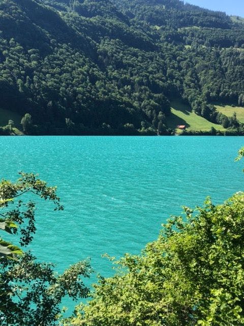
We watched a group of climbers leave for the nearby glacier, observed the Swiss helicopter land and take off, then prepared ourselves for the long walk down towards the Oeschinensee. I thought we would have wonderful views of this pretty glacial lake for most of the downward journey, but this is not the case.
We paused for a drink at the Oberbärgli and walked to a field at the side of the chalet, which ended in a steep drop. We peeked over the edge and there, in all its sparkling glory, was the Oeschinensee. It is from this point that the aqua-blue waters are on your left as you make your way down.
 Hikers resting at the top
 View towards Kandersteg
 The Blümlisalphütte
You have to walk around part of the lake's circumference before branching off to Kandersteg, and you can choose to do more downhill walking on the trail, or journey along the road (partially uphill) to the gondola, which once was a side-facing chairlift. This takes you down to the village and saves your knees a little! We were very tired, hot and hungry when we arrived at our hotel in Kandersteg, but we had a wonderful sense of achievement!
 The long walk down...
 ..and the magnificent Oeschinensee
 Path cut into the mountainside
 Contrast of the blue sky and the aqua lake
Kandersteg was quieter than I remembered- less touristed than in the 1990s- probably due to the strength of the Swiss Franc (CHF). We passed one large hotel that had obviously been closed for some time. Other places had hardly changed in 30 years. It's a pretty village, overlooked by the mighty Blümlisalp, and definitely worth a visit. It is here that cars are loaded onto specially-made railway trucks for the journey through the Lötschberg Tunnel to the alps of the Valais (the tunnel is for trains only). People remain in their cars, tune into the tunnel's radio frequency (for safety reasons) and enjoy the 15-minute journey before breaking out into the sunshine once more and descending to Goppenstein and Brig.
 View from above Kandersteg
 Kandersteg and its beautiful old chapel
DAY 17- KANDERSTEG TO LAUENEN 8/8
Unfortunately, wet weather was forecast again, plus we were tired from the previous day's walk, so we decided to postpone the planned walk over the Bunderchrinde to Adelboden (and we actually completed this 2 years later: see the blog 'Via Alpina Part 3'). I would advise anyone attempting the Via Alpina to have a rest day in Kandersteg before the next hike.
We took the train back to Spiez and then to Gstaad via Zweisimmen. Before taking the postal bus to Lauenen, we decided to have a quick walk around the main part of Gstaad (otherwise known as the "Perfume Mile"). The opulent shops did not have any prices on display- a true indication of very expensive merchandise! Also, Gstaad station is the only place I have seen a vending machine full of specialty cheeses!
 Cheese vending machine in Gstaad!
 Fang, Lauenen
 Lovely chalet near Lauenen
 On the road to the Lauenensee
Our Lauenen hotel (Hotel Alpenland) was out of the main village in a place called Fang (which is really just a group of chalets), and not too far from the Lauenensee of my Swiss calendar. We enjoyed friendly service and a lovely view from our balcony. Clear weather was forecast so we decided to wait until the following day to visit the lake.
DAY 18- LAUENEN TO BERNE
The sun was shining, so we set off after breakfast, walking up the Hinterseestrasse, past the beautiful chalets (showing that the wealth of Gstaad spreads further than just that village!), and up the steep roadway. The forest suddenly opens into the beautiful Lauenensee, which was just as breathtaking as my calendar photos had promised. There were lingering clouds, but these only enhanced the overall lighting of the photos- see if you agree!
 The Lauenensee did not disappoint...


After such a beautiful and peaceful walk we packed our bags and caught the postal bus (which conveniently stops just outside the Hotel Alpenland) back to Gstaad, then train to Spiez and on to Berne.
Berne is the capital of Switzerland (many people think it's Zürich or Geneva!), and it is a lovely old city with cobblestoned streets and arcades of shops. I love walking around the streets, browsing in the shops and looking at the historic buildings such as the prison tower, the clock tower, the cathedral and the Houses of Parliament. Check out the statues at the waterfalls in the middle of the main streets (Marktgasse, Kramgassse, Gerechtigkeitsgasse): the one of the ogre eating the children is quite disturbing!

For public transport, there are trams as well as 3 routes of trolley-buses. Our hotel, the Best Western, was within walking distance from the Hauptbahnhof (main station).
As this was our last stop, shopping was definitely on the agenda! No more did we have to worry about extra luggage or extra weight! Do all your shopping at the end of your trip- just make sure you have an extra bag to carry it in! As I had only a small zip-lock bag as carry-on luggage, an extra shopping bag or two was no issue!
We ate our final dinner in Switzerland in a local pizzeria, then turned in early. We had to be up with the birds to catch our train to Zürich, in time for our 11:00 am flight back home. We are already planning a return trip, perhaps to revisit places like Braunwald (in the hope that we see the view this time!), and to tackle the Sefinenfurgge.
I am happy to answer any questions you may have. As I mentioned, I have seen vast areas of Switzerland during my many visits over the years. Please type your questions in the "Comments" section at the bottom of this page, along with your email address, and I will be only too happy to help!
OTHER HINTS:
- Send all emails received from the pre-booked hotels/guesthouses to your smartphone email address so they can be stored in your pocket!
- Take screen shots of any map areas that you may need as a reference.
- The only paperwork I packed was an A4 sheet of our itinerary (printed on both sides), plus my pocket Via Alpina book. An even better idea would have been to take pictures of the relevant pages, store them on my phone and save the extra weight of the book!
- Your partner's phone should serve as a back-up and contain the same material.
- Visit the Swiss Tourism website www.myswitzerland.com for more accommodation ideas. This is where I found the Schlaf im Stroh accommodation in Ratzismatt. It is packed with information and includes maps, apps and history of Switzerland.
- Most Swiss people speak excellent English, as they now learn French, Swiss-German and English at school. Some of the older Swiss folk may not be confident, so it always helps to have a few words of tourist German as I did (we did not visit the mainly French or Italian-speaking parts of the country). My aim is to become a lot more confident in understanding and speaking Swiss-German, and I am doing this by listening to Podcasts in my car!
 Legendary Edelweiss
 Alpine Forget-me-nots
 Beautiful Alpine Rock Cress
SwitzerlandVIA ALPINA (SWITZERLAND) PART 2
DAY 11- ENGELBERG TO ENGSTLENALP: THE JOCHPASS 2/8:
The weather did clear, and our first stop was at the Bahnhof to meet our Swiss friend, Christine, who would be with us until the last 2 days. Backtracking, we made our way from the station to the Engelberg-Trübsee gondolas. These were decorated with flag motifs from all around the world, and it was entertaining trying to pick the country of each one as they passed us in the opposite direction. The path from the top gondola station took us around part of the Trübsee, then up a very steep, winding path to the Jochpass. The snow-covered side of Titlis was visible and we could see skiers taking the opportunity to negotiate the year-round glacial ski slopes. As this walk was relatively short, we had time to stop for refreshments at the Jochpass, which sits at the border of the cantons of Nidwalden and Berne.
We then descended, past many cows (with bells), past the Engstlensee (larger than the Trübsee) to our left, and towards the Hotel Engstlenalp. The 19th-century hotel’s exterior looked a little tired (in need of some paint), but our room was newly-renovated with beautiful views across the Hasli valley (valley of the river Aare) to the alps of the Bernese Oberland, including the northeast side of the Wetterhorn. We had an evening walk past the local farm chalets and milking sheds. The good weather certainly helped our mood, and we have happy memories of our stay at the Hotel Engstlenalp.
DAY 12- ENGSTLENALP TO MEIRINGEN 3/8:
This is quite a long walk, so we had an early start. Our first stop was at Tannalp, firstly to pat the goats which surrounded us, then to purchase some cheese at one of the dairies. We pressed on, the trail partially encircling the Tannensee, with views of Melchsee-Frutt as we climbed.
This walk continues over spectacular ridges towards the Balmeregghorn, then onto the Alpentower restaurant (built in 1999) on the Planplatten peak. If the weather is clear, the lookouts at Planplatten are well worth the short walk. You can, like us, sit at a table for refreshments, taking it in turns to walk to the lookouts and leaving your pack behind to rest your back and shoulders, ready for the long walk down.
For me, it was a rather difficult walk due to hip and knee pain, plus the fact that it was a very warm day. However, the scenery made it all worthwhile, and we finally arrived at Reuti hot, thirsty and tired. The old cable car carried us down to Meiringen and we were happy to take this option, as the descent to Meiringen is steep. How fortunate it was that I had booked a hotel with an indoor pool. Enjoying the cool weightlessness was just what our tired bodies needed!
(NOTE: I attributed the hip and knee pain to the fact that I only had one hiking pole, so I sensibly purchased a matching one at the next village: problem solved!)
DAY 13- MEIRINGEN to GRINDELWALD: GROSSE SCHEIDEGG 4/8
A short walk across the river Aare took us to the beautiful old Reichenbach funicular, built in 1899. This carries you part-way up the powerful Reichenbach Falls (made famous in the Sherlock Holmes stories), and a number of stairways carry you further up the hill and into the forest. Wild strawberries, tiny but full of flavour, grow in abundance here. Eventually the forest opens up into a wide valley, where the track follows the waters of the Rychenbach until Rosenlaui.
We paused for refreshments at the historic Rosenlaui Hotel (dating back over 200 years), then climbed towards Grosse Scheidegg. Cars are allowed to travel on the road as far as Schwarzwaldalp, but onward it is reserved for postal buses only.
The forest thinned out as we gained altitude, and the trail took us close to the rocky base of the mighty Wetterhorn. The final ascent was on a rather steep direct path, whilst the postal bus negotiated hair-pin bends around us. It was an exhilarating feeling standing at Grosse Scheidegg and looking down to the chalets of Grindelwald dotted below us. The weather was closing in so we decided to ride the postal bus, negotiating tight bends and stopping for cow herds (!), down to my beloved Grindelwald.
DAY 14- GRINDELWALD TO MÜRREN (NO WALKING) 5/8 We had today set aside as a ‘rest day’, as we have done almost every walk imaginable in the area. Where do I start?
• First (not 1st; it’s the name of a place above Grindelwald) to Grosse Scheidegg
• Grindelwald to Bort to Schreckfeld to Grosse Scheidegg
• Pfingstegg to Grindelwald via Hotel Wetterhorn
• Kleine Scheidegg to Männlichen and all the way to Grindelwald
• Männlichen down to Grindelwald
• Schynigge Platte to First (an epic day walk, highly recommended), and down to Grindelwald by foot or via the Firstbahn.
One journey I have undertaken more than once is the Pfingstegg to Stieregg walk: a gradual uphill climb with spectacular views back over Grindelwald and across to the eastern side of the imposing Eiger. I mention Stieregg and the east side of the Eiger in the one sentence because both places have been victims of the accelerated melting of the glaciers, noted not just in Switzerland and Europe, but world-wide. Restaurant Stieregg no longer exists: in May 2005, as the hut was being prepared for opening at the beginning of the walking season, the flagpole out the front was observed to be on an angle, and cracks were appearing in the ground. Experts were called in and the alarming conclusion was that the whole piece of land was going to drop, taking everything with it. The Stieregghütte closed for good, and eventually the land fell away, leaving the building overhanging. The Stieregghütte was destroyed for safety reasons and a new place, Bäregg has been erected nearby, on more stable ground.
The reason the land fell away is because the Unterer (lower) Glacier has shrunk away and the permafrost (high altitude soil that remains frozen for more than 2 years in a row) has melted, so it’s obvious what will follow.
We visited Grindelwald in July 2006, and one day we decided on an afternoon swim in the Sportszentrum. The windows of the indoor pool look down the valley and out towards the Eiger, and suddenly it looked like a dust storm had hit the village! We couldn’t understand what was happening (a dust storm- in Switzerland?!) and we were intrigued! By the time we had changed and returned to the car park, it had more-or-less cleared, but we noticed that all the cars were covered in fine dust and the air smelled “earthy”. Later, we learned that we had witnessed the aftermath of a huge rockfall. A large part of the east face of the Eiger had come away, the scale of which could not be appreciated from such a distance- but it was “around half the size of the Empire State Building”, if that helps! Fortunately it was in a fairly isolated area and there were no casualties.
Our ‘rest day’ was spent visiting shops, talking to proprietors and reminiscing about these events and other changes to the village. Another change we discussed was the disappearance of the Oberergletscher (Upper Glacier). In 1991, my husband and I were able to walk from the Hotel Wetterhorn, up a gravel track and into an ice cave carved into the glacier. Inside its remarkable aqua walls there were ice carvings to admire. Very old pictures show this glacier’s “tongue” reaching down to the edge of the village, so little had changed in centuries- until the ‘90s. In the 30-odd years that have passed, what remains of the glacier is so far up the pass between the Wetterhorn and the Schreckhorn that it is not really worth the long walk up the specially-built stairway to reach it. And the number of wooden steps is ever-increasing.
The final part of our ‘rest day’ was spent making our way to Mürren (train to Zweilütschinen, train back up the next valley to Lauterbrunnen, cable car to Grütschalp, then train across to Mürren). We met our lovely chalet hostess, then had time to explore the village before sunset and fall in love with the place all over again! I found the chalet thanks to Google Earth, and discovered that the owner is an English woman who married a local man and has lived in Mürren for most of her life. It was very close to a supermarket and not too far from the Schilthorn Skyway. We planned to take this the following day to shorten our walk over the Sefinenfurgge to Griesalp.
DAY 15- MÜRREN to GRIESALP 6/8
. . .
Rain had set in overnight, so we decided to give the Sefinenfurgge a miss, having learned from our Richetlipass experience! Instead, we followed the trail alongside the railway back towards Grütschalp, and then took the path down to Lauterbrunnen. The water of the almighty Staubbach falls can be heard gushing over the enormous drop down to Lauterbrunnen, but only small streams can be seen (and crossed) at various stages of the walk. The weather brightened a little but we decided to continue by train to Spiez (via Interlaken), then to Reichenbach im Kandertal (which has nothing to do with the Reichenbach falls from 2 days ago!). The Kiental-Griesalp bus leaves from the train station, traversing the steepest postal bus route in Europe! It is a smaller bus than normal, and it’s a left-hand drive, which helps the driver to negotiate the road. We were riding with a group of teenagers going on camp, and all the singing, then screaming and shouting coming from the back of the bus only added to the adventure as the driver skilfully took the bus around the tightest of bends and the narrowest of gaps in the rock! The driver showed us a picture of the Tschingelsee, a lake formed in 1972 after severe weather, but water drainage over the years means that it is now a large area of nature-preserved wetlands.
EDIT: In June 2022 we were finally able to complete the Sefinenfurgge hike. We stayed overnight in Mürren and completed a short (but steep) walk up to the Rotstockhütte with another overnight stay there to wait out the weather. The hut was filled to capacity with hikers travelling in either direction; the food was basic but good and hearty, and the sleeping quarters were pretty crowded. The bathrooms are in a separate building and you can at least sponge yourself down, but there are no showers. The day of the pass hike was dry but a little cloudy. The Schilthorn summit is clearly visible as you walk; the actual pass is narrow and has limited space to sit and admire the views, and the walk down to Griesalp is initially steep and a little treacherous due to shale underfoot. Steps up and down from the actual pass do help, and (as usual) I wouldn't recommend attempting this in wet weather!
The rather crowded dorm beds!
Last steps before the top!
Celebratory kiss!
The steep walk down
.
.
.
In 2017 and on our return trip in 2022 we stayed at Berghaus Golderli, a very quiet little chalet with basic rooms, but certainly not basic food!
The three of us shared a bunk room and there were shared bathrooms, but this was no issue when we were the only ones on our floor. Other rooms were open and we were able to admire the beautiful carved wood on the beds and wardrobes in the Doppelzimmers. The quality of food at Berghaus Golderli was excellent, which was surprising for such an isolated little village! On our after-dinner stroll (in 2017) it was obvious that the weather was clearing, and we could see where we were to be walking the following day.
DAY 16- GRIESALP TO KANDERSTEG: THE HOHTÜRLI 7/8 The day, as expected, dawned bright and clear. After a delicious breakfast we set off around 7:30 am, ready for our most epic (and highest altitude) walk.
The initial part of the walk is along the Steinenberg road from the Golderli, across a field and up through a forest. The forest soon opens out into grassland and, after a rather steep climb, the Berghaus Bundalp becomes visible. We knew what lay ahead (and we could see exactly where we were headed), so we decided not to stop.
he last relatively flat section was along the road from the Bundalp, then the path started its massive uphill climb. At one point there were 2 rungs embedded into a vertical face of rock: make sure you have somewhere to stow your poles, as you need both hands free to climb- or use teamwork!
The last part of the climb is mostly rock, as the grass thins out the more you ascend. Looking back towards Griesalp, between the mountains, you can make out the Thunersee, Thun and, if it's clear, you can see as far as the German Alps! The Schilthorn is also visible over to the right.
When you reach the chain 'rope' to help pull you up the rock stairs, you know you are almost there, and you can probably see the top (though you may not realise it!). It came as a bit of a surprise when we reached the multi-directional yellow signs, signifying that we had reached the Hohtürli pass! There were hugs and kisses, many photos taken, and celebratory drinks at the Blümlisalphutte, another 70 or so metres up from the pass.
We watched a group of climbers leave for the nearby glacier, observed the Swiss helicopter land and take off, then prepared ourselves for the long walk down towards the Oeschinensee. I thought we would have wonderful views of this pretty glacial lake for most of the downward journey, but this is not the case.
We paused for a drink at the Oberbärgli and walked to a field at the side of the chalet, which ended in a steep drop. We peeked over the edge and there, in all its sparkling glory, was the Oeschinensee. It is from this point that the aqua-blue waters are on your left as you make your way down.
You have to walk around part of the lake's circumference before branching off to Kandersteg, and you can choose to do more downhill walking on the trail, or journey along the road (partially uphill) to the gondola, which once was a side-facing chairlift. This takes you down to the village and saves your knees a little! We were very tired, hot and hungry when we arrived at our hotel in Kandersteg, but we had a wonderful sense of achievement!
Kandersteg was quieter than I remembered- less touristed than in the 1990s- probably due to the strength of the Swiss Franc (CHF). We passed one large hotel that had obviously been closed for some time. Other places had hardly changed in 30 years. It's a pretty village, overlooked by the mighty Blümlisalp, and definitely worth a visit. It is here that cars are loaded onto specially-made railway trucks for the journey through the Lötschberg Tunnel to the alps of the Valais (the tunnel is for trains only). People remain in their cars, tune into the tunnel's radio frequency (for safety reasons) and enjoy the 15-minute journey before breaking out into the sunshine once more and descending to Goppenstein and Brig.
DAY 17- KANDERSTEG TO LAUENEN 8/8 Unfortunately, wet weather was forecast again, plus we were tired from the previous day's walk, so we decided to postpone the planned walk over the Bunderchrinde to Adelboden (and we actually completed this 2 years later: see the blog 'Via Alpina Part 3'). I would advise anyone attempting the Via Alpina to have a rest day in Kandersteg before the next hike.
We took the train back to Spiez and then to Gstaad via Zweisimmen. Before taking the postal bus to Lauenen, we decided to have a quick walk around the main part of Gstaad (otherwise known as the "Perfume Mile"). The opulent shops did not have any prices on display- a true indication of very expensive merchandise! Also, Gstaad station is the only place I have seen a vending machine full of specialty cheeses!
Our Lauenen hotel (Hotel Alpenland) was out of the main village in a place called Fang (which is really just a group of chalets), and not too far from the Lauenensee of my Swiss calendar. We enjoyed friendly service and a lovely view from our balcony. Clear weather was forecast so we decided to wait until the following day to visit the lake.
DAY 18- LAUENEN TO BERNE
The sun was shining, so we set off after breakfast, walking up the Hinterseestrasse, past the beautiful chalets (showing that the wealth of Gstaad spreads further than just that village!), and up the steep roadway. The forest suddenly opens into the beautiful Lauenensee, which was just as breathtaking as my calendar photos had promised. There were lingering clouds, but these only enhanced the overall lighting of the photos- see if you agree!
After such a beautiful and peaceful walk we packed our bags and caught the postal bus (which conveniently stops just outside the Hotel Alpenland) back to Gstaad, then train to Spiez and on to Berne.
Berne is the capital of Switzerland (many people think it's Zürich or Geneva!), and it is a lovely old city with cobblestoned streets and arcades of shops. I love walking around the streets, browsing in the shops and looking at the historic buildings such as the prison tower, the clock tower, the cathedral and the Houses of Parliament. Check out the statues at the waterfalls in the middle of the main streets (Marktgasse, Kramgassse, Gerechtigkeitsgasse): the one of the ogre eating the children is quite disturbing!
For public transport, there are trams as well as 3 routes of trolley-buses. Our hotel, the Best Western, was within walking distance from the Hauptbahnhof (main station).
As this was our last stop, shopping was definitely on the agenda! No more did we have to worry about extra luggage or extra weight! Do all your shopping at the end of your trip- just make sure you have an extra bag to carry it in! As I had only a small zip-lock bag as carry-on luggage, an extra shopping bag or two was no issue!
We ate our final dinner in Switzerland in a local pizzeria, then turned in early. We had to be up with the birds to catch our train to Zürich, in time for our 11:00 am flight back home. We are already planning a return trip, perhaps to revisit places like Braunwald (in the hope that we see the view this time!), and to tackle the Sefinenfurgge.
I am happy to answer any questions you may have. As I mentioned, I have seen vast areas of Switzerland during my many visits over the years. Please type your questions in the "Comments" section at the bottom of this page, along with your email address, and I will be only too happy to help!
OTHER HINTS:
- Send all emails received from the pre-booked hotels/guesthouses to your smartphone email address so they can be stored in your pocket!
- Take screen shots of any map areas that you may need as a reference.
- The only paperwork I packed was an A4 sheet of our itinerary (printed on both sides), plus my pocket Via Alpina book. An even better idea would have been to take pictures of the relevant pages, store them on my phone and save the extra weight of the book!
- Your partner's phone should serve as a back-up and contain the same material.
- Visit the Swiss Tourism website www.myswitzerland.com for more accommodation ideas. This is where I found the Schlaf im Stroh accommodation in Ratzismatt. It is packed with information and includes maps, apps and history of Switzerland.
- Most Swiss people speak excellent English, as they now learn French, Swiss-German and English at school. Some of the older Swiss folk may not be confident, so it always helps to have a few words of tourist German as I did (we did not visit the mainly French or Italian-speaking parts of the country). My aim is to become a lot more confident in understanding and speaking Swiss-German, and I am doing this by listening to Podcasts in my car!
Read similar posts